04 August 2007

The Devil's Tower and Beyond

Our route today ended at the town, Americans call it a city, of Keystone, SD. We had thought about going to Sundance but gave it a miss to add another 40 miles to the days mileage.

We decided last night to go to The Devil's Tower. It was in the direction we were going in and it would, as I wrote above, add another 40 miles to the journey today but that didn't matter.

We set off a little earlier and I was going to buy some 'gas' but the price in Buffalo was $3.13 a gallon (USA gallons are 6 pints, not 8) regardless of the gas station and I'd seen it cheaper that that. We had half a tank which was enough for the day. I pulled off just after Gillette,WY, (look it up, it's real) and filled up at $2.92 a gallon – seems like the same rip-off happens over here as it does in the UK. Anyway, we noticed that there was an increase in the number of bikers and not just ones or two. This was in fours and fives and quite frequent! We wondered what was going on. Well, we had heard that there was some sort of motorbike rally in Sturgis, SD, but hadn't really thought about it much, until now.

We pulled off I90 and headed north up to the Devil's Tower. Again there was an increasing number of bikers. These were not young men with nasty grubby machines that looked like a good wash wouldn't hurt them and that applied to both machine, men and women! They were principally in their late 40s, 50s and 60s. The majority had leather wear on but more common were the grey beards, glasses, jeans and a 'chick' – probably wife or current partner – on the back. These were no hoodlums. What was interesting even more so was the lack of helmet wearing.

The landscape changed from scrub land to pastoral. The hills were much more rolling, there was green grass that didn't look as if it had been watered by anything other than rain; differing varieties of trees, not just different pines. And then thrusting out of this landscape was a huge upthrust of rock. It was so incongruous in the setting. There was a scenic pullout which we pulled into and took some pictures. Off we headed again and now the bikers were beginning to swarm like bees around honey pots; they were more numerous than cars. It's difficult to describe to someone in the UK what it was like but believe you me, this wasn't just one or two, this was forty or fifty we were seeing. The closer to the monument the more there were. All were very respectful of the law, no breaking of speed limits; staying in lanes; not swerving between cars; they were behaving themselves and acting as responsible citizens.

We pulled into the parking lot at the monument, the USA's first national monument, and got out. The air was scented heavily with ponderosa pine and the day was beautifully hot. The Devil's Tower is a massive volcanic plug that has been left after the surrounding rock has weathered away. It's one of those that you hurt your neck looking up at it. It's made of basalt and where it cooled the rock has crystallised into hexagonal columns. They are massive. It was spectacular to walk around the base and see the different aspects of it. There were climbers trying to get up it. We saw at least four groups. The sides of this thing start out shallow and quickly slope upwards and then are vertical. Goodness knows how you get to the top other than climb. Someone did do a parachute drop onto it!

Surprise, surprise there were plenty of bikers here too! There were even parking bays put aside for them. Obviously they were expected. After an hour and half we started back down and stopped off at the stores near the entrance to the monument. There were many, many more bikers now. At a guess there must have been easily 200 and they were catered for. Now we noticed marquees that had been set up selling biker orientated goods. All were friendly and there was a great camaraderie amongst them.

As we headed out of the monument area we spotted some prairie dogs and pulled over. They are pests in the wrong place but in the right place, here, they are so cute. Rather like meercats they stand up on their hind legs. There was a couple boxing and another pair just standing looking around.

Off we headed to our next stop. In this case we thought some food and a coffee were in order. Just at the state border, Spearfish, we pulled in and picked up some vittals which we ate at a rest area a few miles down the interstate.

Our next stop, which you'll notice I've not mentioned 'till now, was Deadwood; yes, that one of Calamity Jane and Wild West fame.

The number of bikers had decreased however...

Just as we hit the outskirts there were two lots of bikini clad, mostly well figured and endowed, young ladies offering to clean cars! I nearly drove into the kerb in surprise as I thought it was the sort of thing one only saw in the movies or tv series.

On entering Deadwood it was like entering Biker City. There were bikers of all types, shapes and designs- mostly Harley-Davidsons. Some were obviously showing off by riding up and down the main drag; the bikers were on the sidewalks and all were very amiable and although there were obviously drinking there wasn't anything nasty. The noise was slightly overwhelming from some of the motorbikes. A point to note in differences in language what we call a multi-storey car park, here in the USA is called a parking ramp. We parked in a parking ramp and went for a walk. It was sight to behold – down one side of the street was a continuous line of parallel parked bikes. The shine of the chrome and stainless steel; the coloured windshields; large panniers; small panniers; seats of leather; seats covered in fleece; bikes with long handlebars; most were short. The clothes were much as described before except there were a few woman wearing bikini tops and a few who shouldn't have been wearing them. There was even a naked biker, riding his bike along the main drag I might add with his partner, female and fully clothed, sitting behind him.

We ended up in the Adams Museum giving a good run down of the history of Deadwood. It's worth looking at website as the picture showing the main street is quite different from the way we saw it. The town itself has been revived and restored. The architecture was fascinating and worth looking at.

After about an hour and half we decided that our ears needed some quiet. The satnav helped us out of the town and set us on the right track.

We had discovered in the information centre about the bikers. The nearby town of Sturgis has been holding a bike rally since 1938 and it has grown. It seems that several hundred thousand bikers descend on the town and surrounding area. Again, it's worth a look at the website as it's the town that runs the event. As we headed for Keystone we saw any number of bikers; groups of them; long tails of them; sometimes there was the odd individual but mostly in groups and mostly men but there was one or two women bikers; they were on both sides of the road; slowly the numbers decreased until...

We reached Keystone where it was like a miniature version of Deadwood regarding bikers. However I wanted to know where Cary Grant and Eve Saint Marie were in 'North By North West' when they were here for this is where the climax of the film takes place. Well, it's at the Mount Rushmore memorial nearby but some of the action took place here! It's been a superb day with the weather, scenery and the bikers!

Tomorrow it's Mount Rushmore and the Wind Caves.

03 August 2007


Today it's the Little Big Horn!


The weather until now has been good in the morning and cloudy in the afternoon. It was the reverse today, cloudy this morning with rain. As a prelude to today, last night we were listening to 'Round the Horne' on BBC7. The story was 'The Palamino Kid' a skit on westernsand it just seemed so very appropriate.


We set off for Little Big Horn but made a diversion to a Wal-Mart. There were one or two items that we had to get. I used my credit card and the poor chap couldn't get his terminal to accept our address and then the card reader wouldn't read my card, there's no magnetic strip as such and the card reader couldn't do chip and pin!


Whilst in the store the heavens opened and it poured down in a deluge. Even after we set out on the road it remained overcast. The scenery was very much the same as before. We arrived at the Battle of the Little Big Horn memorial site.


The area is high and undulating hills with sharp ridges dropping to a plateau with the river running along the bottom of the hills. There were forested areas below and it's easy to see how the battle took place. The museum gives a very fair and balanced viewpoint from both sides. I would imagine that 20 years ago it would have been quite different. The whole situation leading up to Custer's death was a disaster waiting to happen. It seems to have ill-planned and ill-led. There were talks given by the rangers and one of the talks made a very significant point. He pointed out that for all the 'advanced' technology that Custer and his men had, it failed – the guns took too long to load, even the pistols. The Natives were technologically backwards but their weapons – knives, bows and arrows, hatchets – all worked and they defeated the troops. Now, doesn't that sound just like a certain Asian war where the 'backward' peasants defeated the technologically advanced Americans. Enough of this philosophising and back to what we did. We must have spent a good two hours there as we also did the self-guided auto-tour. That was interesting as it built up a pattern of the troops being gradually winnowed down in a series of skirmishes and the 'Last Stand' was the climax. All in all it was very good.


The weather by this stage was quite stable and sunny. It was time to move on and we headed off to Buffalo. Again, the scenery was much as I've described earlier. The area we were travelling through is where the Rockies meets the plains. The road, an Interstate, was good and fast, up to 75 mph. When we arrived we noticed that there a 'Hoot and Howl' restaurant and bar attached to the motel. The name says it all but the food was good.


Tomorrow, Saturday, it's Sundance, Deadwood and a stay near Mount Rushmore.

Cody to Laurel


Another short journey day today. It gives us time to look around some of the towns we stop in otherwise it'd be just one drive after another.


Today we go up into 'The Big Sky' state, Montana. There's no sales tax! We moseyed along to the Buffalo Bill Historical Center, '5 museums in one'. The five museums are: Buffalo Bill Museum, what else; Draper Museum of Natural History; Plains Indian Museum; Cody Firearms Museum; Whitney Gallery of Western Art


The two of the five that we didn't do were the Plains Indian Museum and the Western Art ones so I can't write about them. You walk into the lobby and the five museums split off from that; quite clever. We first went around the Buffalo Bill Museum. Fairly obvious what it was about and it did it very well. It showed his life story fairly and without embellishment. He did lead an exciting life when he was young but when he went into show business the events of his life and the show business side blurred and it was quite fair to explain that all the stories about him were not made up by him but by others who used him as a cypher for the 'Wild West'. The Wild West show he ran he was at pains to point out was nothing more than that, a show. It caught the public imagination so much that they believed it to be the truth rather than a fanciful show. It didn't seem to make claims about him that were unrealistic, unlike one or two exhibitions we've seen. On show were various artefacts from his life including clothes, saddles, newspaper articles,etc in fact, all the things you would imagine there should be as well as exhibits about some of the other people involved. Overall not too bad.


If ever there was an exhibition dedicated to slaughter the Firearms Museum is it. It was a relentless exhibition about firearms, which pretty much speaks for itself. However the first item on show was a machine gun of the type used in 'Carry On Up the Khyber' where Terry Scott and Charles Hawtry use one to try and shot the invading Burpas. All I could do was look at and ask my partner where the gramophone records go - if you don't get the reference watch the film and you'll get it. With 1,500 guns on show on the upper level and another 1,200 on a lower one it was a touch overwhelming. A one-theme exhibition that got tedious fairly quickly and we both headed out after about 10 minutes.


The Draper Museum of Natural History couldn't have been more different. It presented the natural history of the area in a series of levels representing the different heights. It was very interactive and quite beautifully done. Starting at the highest level one spirals down through different exhibition areas. The quality and standard of the information and exhibits is extremely high. There are glass panels in the floor that one can walk over showing what goes on under the ground too.


After a coffee and bun in one of the cafes we wandered down along Sheridan Avenue. It was quite typical of other towns we had visited but more touristy. It wasn't overwhelming or showy but quite pleasant.


We followed the satnav instructions for leaving the town and headed on up to Laurel until... we got to the state border. Going along we had noticed that the scenery was changing; the hills were becoming flatter and more distant; the signs for road works that had been showing for 30 miles or more has disappeared. So, it was a bit of a shock when we were flagged down for road works at the state line. We were told it was going to be about ten minutes and we had time to get out and stretch our legs, which we did. The woman chatted with us. She was a Montanan but lived about 350 miles north and worked doing the traffic control for about a 10-12 hour shift! She had been brought up on one of the reservations so we guess that she was a real native American! The pilot car arrived and we headed off, followed by a long line of traffic. The work was extremely extensive. The road was being ripped up and replaced by new sections. This went on for about three miles. The pilot car pulled off ready to take the next group across avoiding the trucks and on we went. The road became normal until we realised that the works covered a much larger stretch, in fact they went on for 10 miles on and off. The authorities were widening and renewing the road in huge sections. This wasn't even a highway but an ordinary road.


It wasn't long after that we saw signs for Laurel and we could smell it too! As we hit town we could see that there was a small oil refinery and a large railway junction and sidings. It's the most industry that we've seen so far, not that we have been in areas that are likely to be industrial. We found the motel and settled in. As we had arrived quite early for once we headed up to the town of Billings for a look around. We picked up some groceries for our evening meal, including a bottle of white wine. To cool it quickly we get ice from the ice dispenser put it into the sink with some water and roll the bottle around. It gets the temperature down quite quickly.


Tomorrow it's off to Little Big Horn!

02 August 2007

Yellowstone to Cody


Last night we had a meal at the restaurant next to the hotel. One of the waiters was there last October. She had gone home to Connecticut but had come back for the season and was living in a shed at present! Not a bad meal.


Anyway today we make our way to Cody at a leisurely pace. We stopped off at a store that we had got coffee at last October and picked up coffee and some buns for breakfast, then headed off to the 45th Parallel to eat them; the parallel is just before entering Wyoming in Yellowstone near Mammoth Hot Springs. From there we headed off back to Canyon Village.


We went back over Dunraven Pass. It has a shear rock face some of which has come away to reveal the underlying structure of massive hexagonal looking columns reaching upwards. Swinging down from there we went to Canyon Village and whereas yesterday we went to Inspiration Point, today we went further along where the parking was a touch easier. We went down a winding pathway and caught a glimpse of one of the waterfalls. However, that was as nothing as to what came next. We were soon standing alongside the top of a waterfall watching the water plunge into the canyon. There was so much mist that where the water settled on the sides it formed streams running back into the river and these weren't little streams. It's a bit of a cliché to write about the boiling, seething mass of water but that is barely adequate to describe the sound and spectacle of watching the water plunge down and hit the bottom.


We must have been there the best part of hour before moving on. We pulled in at Fishing Bridge Visitors Center. We picked up a couple of coffees and single scoops ice cream cones. The single was more like a triple but was it nice! As we sat and ate our ice cream and motor bike with a side car went by, nothing odd in that but there was a dog in the side car and it was wearing goggles!


We were at the top of Lake Yellowstone and is it big or what! Somewhere under that lake is a magma chamber waiting to explode though and take out most of the western world one way or another.


The road took us up to the Sylvan Pass which was an interesting experience as there were road works from the bottom of the pass to the top and down to the Eastern Entrance. It seemed to be one way working and we had to wait fifteen minutes as traffic from the other side had to finish coming across. The journey up was okay but there was heavy machinery and the road surface was gravel. This was also going up the side of the cliff face with shear drops on the right. Luckily with there only being us on the road it was okay. Slowly the convoy spread out and there was a large gap behind us and quite suddenly we were at the entrance and saying farewell to Yellowstone.


A straight drive to Cody until... passing alongside Buffalo Bill Reservoir what do we find but the Buffalo Bill Dam Visitors Center. We've not seen that mentioned or indicated anywhere in the guide books or anywhere else. It's a little gem. There's not much to it but it was an unexpected pleasure. It was one of the first all concrete dams to be built. Originally used to control the water it's now used to generate electricity too.


Leaving that soon found ourselves in Cody and our hotel for the night. We've done just over 1000 miles and this marks the half way point.


31 July 2007

In Yellowstone


Well, another day of incredible scenery. One starts to run out of superlatives to describe it.


This morning we did a little shopping and wandered around West Yellowstone. Unlike the last time we were here everything was open. I bought not one but two pouches. They are so useful to use instead of filling pockets.


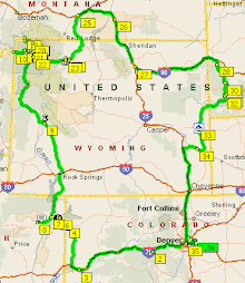
The plan for today was to end up at Gardiner but take a different route to the one we had done before. The map will show our route.


We went up to Norris and past the superb Norris Geyser Basin - a sight to behold in winter – and on to the Canyon Village. We stopped there for a coffee and went into the visitors centre. The NPS had an exhibition about Yellowstone as a super volcano. There wasn't anything there that we didn't already know but it did have a rather unusual globe of the world. It was a large rock globe, some three feet in diameter, with the land masses etched onto it and the main volcanic areas marked in red. That wasn't the unusual thing about it. It was how they made it rotate. It was totally free to spin any direction as it has was supported and lubricated by water being forced under it so that it sat on a cushion of water. As is the way with such things the little sweet hearts were just making the globe spin faster and faster. I actually wanted to look at. So with one hand I slowed it down and the little oik tried to make it spin. I'm pleased to report that he gave up and disappeared leaving me, tee hee, to look at it properly. It was very easy to manoeuvre and position the right way up and then spend a few minutes actually looking and studying it.


Upstairs they had some very good displays showing where volcanoes and earthquakes had occurred since the 1960s built up on computer screens and a display showing the seismic activity in the area.


On driving out from the Canyon Village we did a tour of the 'Grand Canyon of Yellowstone'. This was an auto-tour, what else in the USA!, and did we encounter slow moving cars and some very odd parking practices. However, the first view we stopped at was at the Virginia Falls. These were magnificent. At some point I will put together a site showing some, not all of the pictures taken as that's the best way to appreciate them. These falls, like the Lewis Falls mark the edge of the Yellowstone caldera. It was like a version of the Grand Canyon in one valley. There were one or two wingey characters of the 'what's so special about these' variety. They wanted to go out on the promontory and do something – like drop off hopefully.


As a side note, some of the areas that we've passed through have been as spectacular as Grand Canyon. Some have been like Death valley with greenery. Quite stunning. What takes one by surprise is the sudden shift in scenery; one minute you're driving through a magnificent, steep sided canyon and then you're out on a plateau and the transition is so sudden.


We didn't stop at all the points as they looked rather crowded and difficult to park sensibly. We got back to the Grand Loop road and towards Dunraven Pass. The roads were steep and twisty but easy enough to drive. We stopped just after the pass for some pictures and as it started to rain decided to head on towards Tower Falls.


Tower Falls was where we had tried to get to last October but failed due to the snow. This time we would make it. Up, down, twisty roads and past Mount Washburn where we stopped and looked out across the main caldera, which is completely covered in trees. Soon we arrived at the Falls and despite it looking busy we stopped and took the requisite pictures. One little thing amused us. We had seen lots of older looking bikers, grey haired, beards, sun glasses, leathers, no helmets, (and that was only the women!) bandanas – basically, the works. Just as we got to the falls there were some bikers putting on white coveralls to keep off the rain! What wimps or didn't they want to get their nice leathers/denims wet?


Again these Falls were fantastic and quite spectacular. As we're going to be heading that way again on the way to Cody we'll probably drop in on them again or at least some of the other viewpoints.


As we swung up towards Mammoth Hot Springs and Gardiner we were travelling on the road that we had planned last October when all the snow stopped us. As we swung around a bend there were the Undine Falls, the furthest that we had got the last time we were here. We pulled off the road and I filmed the falls again but this time we ventured down to the top of the falls and I have gotten some amazing footage of the falls from directly above. They were just as amazing this time as before but easier to get to.


We made our way to Gardiner, stopping off at the same store as last October but the same woman wasn't there. So it was then off to the motel.

Up to Yellowstone from Pinedale

What a day! But before we start on that we've had two injuries. Well, one injury and one assault by a deadly insect. They both occurred two days ago. My partner was bitten on the side of the leg by some dastardly British hating insect! A rather nasty swelling grew but some good British anti-histamine has dealt with that. It just looks a strawberry birth mark at present. The other injury happened just after I had soaked my feet after wearing my new boots. I walked out of the bathroom and someone, who shall remain nameless, had left her bag just outside the bathroom door. The little toe on my left foot made deadly contact with it and I felt the usual sharp pain. I did hop about but refrained from the usual expletives that accompany such acts. It was a few second later that I noticed the little blood splatters on the tiles and then the carpet. On examining my little toe it would seem that not only had I gashed the toe but managed to tear up a piece of the nail. Some additional bathing in water followed by a frantic search for plasters, which were out in the car, an application of the aforementioned plaster and the toe seemed okay. Of course, the only thing now is that i can only wear trainers for a few days.


Back to today. No mistakes in directions today. All we had to do was to follow the route signs for the 191, which we did after breakfast. The tone for breakfast was set when I rescued a lady from the coffee machine when it refused to stop dispensing coffee. To cap that and I had near hysterics over this, everytime the two toasters were used the breakfast room lights went out. It happened not once but twice. At any moment I expected Basil Fawlty to appear muttering about inconsiderate guests and how dare they abuse the toasters. No such thing happened of courseas theduty manager took it all in her stride. Ayway, we set off.


As before the scenery was amazing. Heading out of Pinedale, a town that is trying to make something of itself, the scenery was more varied than entering it. Instead of rather bland, flat land either side, there were cliffs coming down to the road edge and flat land on the other. On our left there were the Tetons looking like a child's drawing of a series of mountains; all sharp peaks and snow on the top, well a bit anyway. Ahead there were more of the same but in the distance. To the right there was flat land and mountains in the distance there too. We managed to keep up a steady speed. The traffic, by UK standards, was quite light. The road was easy to drive and flat.


However, what makes it all so different is the dramatic nature of the scenery. Living in the UK there is no part that hasn't been altered by humans in some way over the last 10,000 years; here it's quite different the scenery has been touched at all in that time and there is little or evidence of human interference despite what one may read elsewhere and even where people have settled, apart from the cities and towns, this is still the big country.


Anyway less of the philosophy and more of what's been happening. We were driving through a canyon, following the course of the Snake River, with sharp cliffs either side and the river below. The towering cliffs were dramatic but softened by the pine tree and then, quite suddenly, we were in the open and there was of greenery, a sure sign of increased population and traffic lights appeared – the first for over 60 miles. We were on the outskirts of Jackson, or Jackson Hole, which ever it is, we were there. Where the traffic came from I've no idea because it certainly wasn't there driving up.


We passed shopping malls and apartments and various turn-offs. Then there appeared a sign to Historic Downtown Jackson. It was amazing from nothing to being in the middle of a hurley-burley of traffic coming at us from all sides; four way junctions; rotund people crossing the roads in strange places; bikers with peculiar walks; it was as if the town was coming to cave in on top of you. Despite a seeming chaos we found a place to park; all very clearly marked and not overly full. We made our way back to the town centre (Historic downtown).


Jackson is a town on 'speed'; every morning it seems that someone injects it with something that makes it go at hyperwarp speed to the ninety nine. The cars, the oversized RV's; the bikers with strangely coloured Harleys (one was pink!); the people of all different shapes, sizes, ages (some very strangely dressed for their age), the different clothes; the stagecoach being hooted at; the hustle and bustle; the shops of over-priced clothes and distinct lack of coffee outlets. The ice cream parlours and distinct lack of What a place! Don't get me wrong; it's not a bad place but it's expensive what with the shops selling overpriced clothes, haute-coutier cowboy clothes is a good one. It's not a cheap town. Anywhere else I think it would have degraded into cheap and tacky but here they've managed to put 5th Avenue, Oxford Street and Union Square with some elements of the glitz of Las Vegas all into the equivalent of two town squares with the same number of people and it works!


Jackson is not a typical Wyoming town or city by anyone's stretch of imagination but it's wonderful in that way only American can make it.


We left town and headed northwards. We decided to stop about three-quarters of an hour later at Coulter Bay junction where there was somewhere to buy something to eat and drink. Just as I approached the shop a thin little streak of across my path. It was a chipmunk. The man operating the cash till was from Kentucky and we a little chat with him.


We sat outside on a log eating a sandwich, bun and drinking our coffee. It was all very pleasant and cool. After cleaning the windscreen We headed off into the Teton National Park, which had a separate entrance for pass-holders, us – membership has it's privileges. The Tetons were just another point for us before Yellowstone. However, it was a spectacular view and the drive was easy. Through the Teton Pass; not quite the same as other passes we've been over. It was like being in Yellowstone before getting there.


We arrived at the entrance to Yellowstone; had our pass checked and proceeded along through an avenue of pine trees that seem typical of entering this park. Our first stop was going to be Lewis Falls. Nothing spectacular in terms of height, 30 ft, but it marks the edge of the Yellowstone caldera.


As we approached it my partner fell into conversation with a couple from Florida who were doing a year long tour of the USA! What a character the wife was! Very garrulous and interesting with it. We had quite a little talk. She took a picture of us both and we'll probably end up on her blog!


We pulled in at the West Thumb Geyser Basin and had a walk around that. The colours of the water ranged from a startling turquoise blue to reds and oranges. There were little bubbling mud pools and very young geysers. We caught the occasional whiff of a sulphurous air but it was different from last October. There were many more people but it wasn't crowded as I thought it might be and the roads weren't too bad either.


On we headed and stopped next at Old Faithful. The hunt for the webcam was on my mind! Where was it? Anyway, we walked around Old Faithful and found a spot to watch it that was better than the standard view. It was where the expelled water ran into the river. We waited for the next eruption and it was quite as amazing as ever. After a longer delay, after the eruption had subsided, than we imagined the water started to flow and it was quite a little spectacle in itself.


I went into the Visitors Center and actually asked where the cams were and they were quite obvious, once you knew where to look and, I was told, they are hoping to make it a live cam so you can see it happening in real time. Out I went and, much to my partner's embarrassment I paraded up and down in front of the camera; I heard some a family group talking on a cell phone to someone telling them to look at them on the cam!


That kinda ended the day and did the 30 mile drive up to West Yellowstone and found our night's lodging, not quite where the satnav said it would be, hoo-hum.

29 July 2007

From Vernal to Pinedale

A day to dawdle up to Pinedale on 191. There was nothing planned; it was a day to take time to cover the 210 miles and relax.

No free breakfast but that didn't matter. We just repacked the car and set off. All we had to do was to follow the 191. We headed out past the Wal-Mart we went to last night. We didn't want to use the satnav as it was just a matter of following the 191.

The scenery was red, rocky, layered and quite fascinating until we got to a town called Ballard. It occurred to me that we hadn't seen any signs for Pinedale or even Rock Springs. We pulled over and checked the sat nav. Whoops, we had headed in totally the wrong direction for 30 miles! Arrrgghhhh! It was a matter of turning around and heading back to Vernal. There wasn't any other route. Off we headed back post-haste. Off we went. About 35 minutes later we were back in Vernal. This time we went the correct way.

The scenery was equally, if not better than before. The rock formations are incredible. Upfolds, anticlines, synclines, etc. all with different colours. We passed into the Ashley National Forest and the road started to rise again. The road however, was much better than others going over mountain ranges we had encountered before but the reason became apparent a little later. There was a phosphate mining operation roads were good. Up we went even further and the scenery was wonderful particularly as it was sunny and beautifully warm. As we came down form the forest we entered the Flaming Gorge area and that was something. We saw a sign for the Flaming Gorge Dam. Nothing about this had we seen in the guide books. It had been built across the Green River one of the Colorado River tributaries. We caught a glimpse of a bridge which we soon traversed. A wonderful bridge that seemed to fit into the scenery quite naturally. A short distance got us to the dam. We stopped and had a little look. There was a visitors center and it was possible to go on a tour. We didn't go as we would have to taken off all metal objects and left them in the car. People with pacemakers were equally urged not to go.

We started off again; got up onto the I80 and off again. The next part was dull in comparison. If anything it ended up reminding us of I10, one of the most boring routes we had been on. It wasn't quite as bad but it was very samey; flat scrub land either side and the interesting bits in the distance. We made quite good time and luckily our hotel was highly visible.

Tomorrow we head off to Yellowstone!